DEC 2: As the weather was looking to be nice, I decided I’d head north towards Loja to the Cajanuma Entrance to Podocarpus National Park. This is the largest National Park in Ecuador, and covers many biozones. My plans were to take the bus as I did not want to pay $25 for a taxi. I’d also been told that one cannot get in there til 8:00 AM, so I did not have to get up or leave too early. I suspected the bus would take an hour, so left the house at 6:30 and got to the bus stop at 6:50. I think I was the last one on before taking off. I told the attendant I wanted to go to Podocarpus, and if he could notify me when we were near. He said he would.
The fare was $1.50, so can’t complain about that. Since one can simply wave for an oncoming bus to stop for you, he is not restricted to using the bus stops, so it seemed like we stopped for passengers every mile or two. When we got to the next big town, Malacatos, I had my eye peeled on the sky, looking for Chestnut-collared Swallows. A little research indicated they patronized the large Catholic Cathedral, so I was hoping to catch a glimpse of one. Sure enough, at the bus stop a large flock of swallows flew overhead, and finally one swooped low enough to ID him. Immediately after resuming the trek, the church came into view and the swallows were just swarming around at the steeple-like edifice on top.
I was going to write, “I can’t remember the last time I saw a life bird from a bus,” but I actually can. It was in July of 2009, and it was here in Ecuador. I had flown over the Andes to the Oriente, or Amazon Basin, as I was going to be headed down the Rio Napo to the Napo Wildlife Center for a few days. As the airport in Coca (near the Rio Napo) was “closed for repairs” they flew us into Nueva Loja, and bussed us to Coca, about an hours ride. Along the way I saw 2 life birds, a Crested Oropendula and a Green-breasted Mango, which is a species of hummingbird. Both were an easy ID. The Oropendula is a large bird, and the hummer was sitting on a power line in plain view.
I had brought up Google Maps on my I-phone so knew when we were nearing the entrance. It turned out it was right on the crest of the mountain between Loja to the north, and the rest of the small towns to the south. In a former conversation someone had said something about going “over the hill,” a reference to the ride to Loja. The attendant did not let me down and had the bus stop at the entrance.

ENTRANCE TO PODOCARPUS NATIONAL PARK
I understood that one needed to sign in here, but as it was not yet 08:00, no one was here yet. But luckily someone showed in 5 minutes and I got signed in. It is nice that one can carry a color copy of his passport for most ID issues. I was hoping to catch a taxi or other vehicle headed up the mountain, but none was coming along. But the birding seemed pretty decent. In a few minutes I ran into a mixed flock which included an Azara’s Spinetail, Rufous-chested Tanager, Yellow-breasted Brushfinch and a few Three-banded Warblers. A little farther along were some Great Thrushes and a White-crested Elaenia. Soon after, I spied a Mountain Velvetbreast, a species of Hummingbird.
The birding continued to be decent and I could usually hear or see something. About a mile up the hill I found another small flock which consisted of Slate-throated Redstarts, Brown-capped Vireos, a White-sided Flower Piercer and a pewee species. But as the day wore on and the higher up I got, the birds thinned out, but the view kept getting better and better.

SLATE-THROATED REDSTART
When checking in I had asked the ranger where the best place for birds was, and he said from Km 5 to the refuge (HQ). It was about 9 Km from the highway to the refuge, which is a little over 4 miles. The gravel road was in good shape and almost never very steep. There was a section of pines I went through which was totally devoid of bird song. As there are no native conifers in Ecuador, I surmise that maybe birds are not drawn to these because they are not native. I did have to wonder why a softwood such as a pine was planted here as, in this environment, such would seem to deteriorate quickly. Seems to me that Douglas Fir from the PNW would have been a better choice, but I’m probably biased.
HERE ARE A FEW SHOTS ALONG THE FIRST HALF OF THE WALK


YOU CAN BARELY SEE THE HIGHWAY DOWN THERE


When I reached the small bill board indicating the official boundary for the park, I have to admit I had been grumbling some because of the lack of birds.

But finally a few swallows appeared, as did a raptor high overheard which I got pics of, and I’ll have to send it to someone else for ID since I can’t figure it out. (It turns out the raptor was an immature Variable Hawk - the pic is too blurry to include here) Right after that I saw a Green-tailed Trainbearer, a small hummer with an unusually long tail. But for the last 3 Km or so, it was quite dead for birds, but the habitat seemed about perfect for them. And at least the scenery continued getting better all the time.
At a few points I could see the city of Loja to the north, a city of some 200,000 people sitting at an elevation of 6700 feet.

IN THIS PIC YOU CAN SEE THE CITY OF LOJA WAY OUT THERE
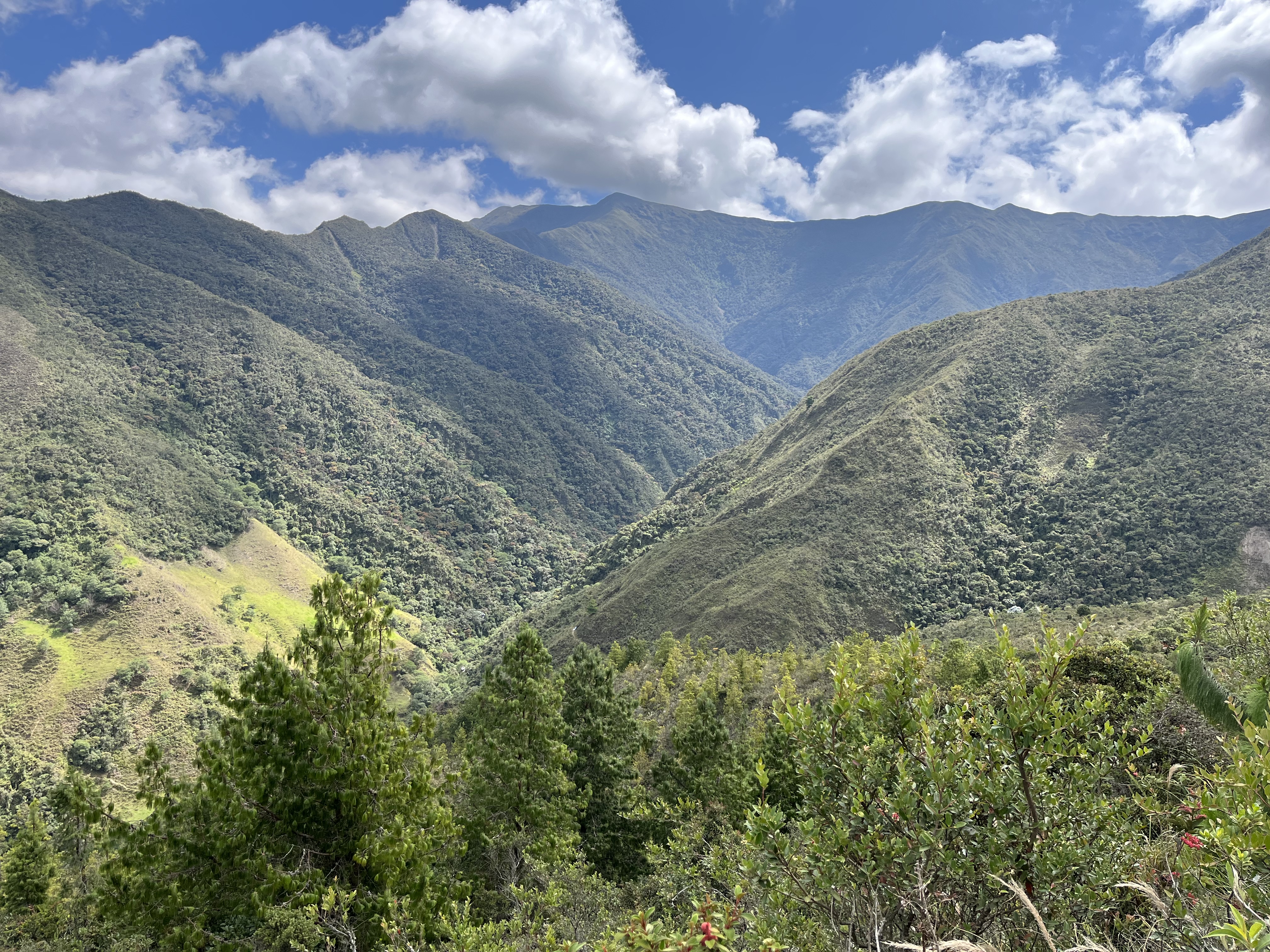
Before I reached the boundary sign, there were scatted remnants of forest, lots of scrub, and plenty of farmland. After the boundary it was only, stunted cloud forest. I’ve often wondered how the conquistadors crossed this barrier. It is so thick and impenetrable, a seemingly formidable obstacle.

IT SEEMS OBVIOUS TO ME THAT I WALKED UP MUCH MORE THAN THE EQUIVALENT OF 10 FLIGHTS OF STAIRS. THE HIGHWAY IS A LOOOONG WAY DOWN THERE.


IN THIS PIC YOU CAN SEE 2 HANGING NESTS. THESE WERE BUILT BY MOUNTAIN CACIQUES. I DID NOT SEE ANY. THEY ALSO GIVE YOU AN IDEA THAT THIS LOOKS TO BE GREAT HABITAT FOR BIRDING.
Sometime back I took my jacket off and put it in my daypack as the day was warming up. But the higher up I got the cooler it became, especially when the clouds blocked the sun. I was too hot with the jacket on and almost too cold without it. Plus, I was feeling the sun beating on my face, and did not have any sunscreen along. And every so often I’d see a bird flitting across the road, or taking off from a tree above me, leaving me no chance to identify it. To top that off, my hearing aids are great for detecting birds, but useless in helping me figure out what direction they were.
When I finally saw a sign that said,”0.6 Km to the refuge,” I began to breathe a sigh of relief. I was getting tired. And soon I finally saw the outline of a building which I assumed was the HQ. But when I reached it, it was only a large storage shed, with a sign that said,”0.7 Km to the refuge.” Hmmm. It was now father to HQ than the last sign. Oh well, in due time I actually did reach the HQ. It also was dead for birds. I talked to the ranger there asking him where to find some birds, so he directed me to a trail nearby. So after a 10 minute breather, I took off on the trail. It was dead also, and when it began going uphill, I turned around. I’d had enough hiking for the day. My altitude app said the HQ was at 9,270 feet. Maybe I’m getting used to the thin air and altitude as I was not getting light-headed.
When I returned to HQ, there was a couple there from France who were with a small group doing some hiking. I asked their driver if I could hitch a ride down the hill with them, to which he obliged. That was really great because I did not want to walk all that way again. But I had to wait over an hour because some of the group were still out on the trails.
It took all of 10 minutes to reach the bottom where they bid me farewell. I learned they were all from France and were flying back tomorrow. So I walked across the road and waited for a bus to flag down. It took about 20 minutes. When I got on, there was no room…………all the seats were taken and the rest were standing in the aisle. I actually stood near the driver on the small area next to the door. Eventually a few got off and I was directed to the front of the aisle where I stood for about 45 minutes, at which time we reached Malacatos. At least half of the passengers got off, so I finally was able to grab a seat. At least this bus was newer than the one back from Tapichalaca, and the roads were better, so in that respect it was a better ride.

THE “SARDINE EXPRESS”
In another 10 minutes we reached Vilcabamba where I decided to take a taxi home. The whole trip cost me $4.50. Guess I can’t complain as I saved $20.00. I’m kind of sore as I write this though. I should sleep well tonight you’d think. My pedometer app says I walked 6.1 miles. But it also says I only walked up 10 flights of stairs. That has GOT to be a mistake. All you have to do is look at my pics. The highway is pretty far below where I’m taking the pic from. And I did manage to eek out a whopping 23 species of birds.
No comments:
Post a Comment